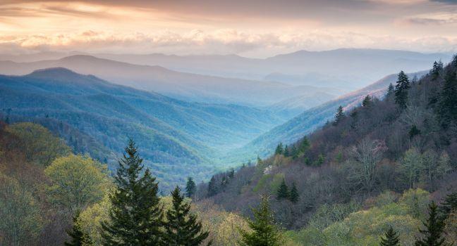
14 Best Sights in Great Smoky Mountains National Park, NC, North Carolina

Background Illustration for Sights

We've compiled the best of the best in Great Smoky Mountains National Park, NC - browse our top choices for the top things to see or do during your stay.

Cataloochee Valley

Fodor's Choice
Essence of Autumn
Danny R. Buxton / Shutterstock

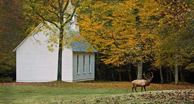
This is one of the most memorable and eeriest sights in all of the Smokies. At one time Cataloochee was a community of more than 1,200 people. After the land was annexed for the national park in 1934, the community dispersed. Although many of the original buildings are gone, more than a dozen houses, cabins, barns, and churches still stand. You can visit the Palmer Methodist Chapel, the Beech Grove School, and the Woody, Caldwell, and Messer homesteads. You have a good chance of spotting elk here, especially in the evening and early morning. You'll also likely see wild turkeys, deer, and perhaps bears. Cataloochee is one of the most remote parts of the Smokies, reachable by car via a narrow, winding gravel road that rises over a steep pass before dropping you into the isolated valley. Take the 5 mph speed limit seriously on the blind curves. At dawn and dusk, this uncrowded valley is pure beautiful magic.

Big Creek Picnic Area

Fodor's Choice

This is the smallest picnic area in the park, with only 10 picnic tables. The creek is wide and inviting, with small swimming holes and several channels that create tiny islands. The picnic area is accessible via Exit 451 off of Interstate 40 or the unpaved Cove Creek Road from Cataloochee. There's a small campground here and restrooms but no pavilion. Several good hiking trails begin here, and the Appalachian Trail crosses the road near the entrance at Davenport Gap.

Deep Creek Picnic Area

Fodor's Choice

Deep Creek offers more than picnicking. You can go tubing (rent a tube for the day for around $5 or $6 at nearby commercial tubing centers), hike about 2 miles to three pretty waterfalls, or go trout fishing. You can even go mountain biking here, as this is one of the few park trails where bikes are allowed. The picnic area, open year-round (but no running water in winter), has 58 picnic tables, plus a pavilion that seats up to 70 (reserve in advance, $32 fee). There's also a campground here.

Recommended Fodor's Video

Heintooga Picnic Area

Fodor's Choice

Located at more than a mile high and set in a stand of spruce and fir, the picnic area has 41 tables. Nearby is Mile High Overlook, which offers one of the most scenic views of the Smokies and is a wonderful place to enjoy the sunset. For birders, this is a good spot to see golden-crowned kinglets, red-breasted nuthatches, and other species that prefer higher elevations. Nearby are a campground and trailheads for several good hiking trails, including Flat Creek. The disadvantage is that, due to the high elevation (and the risk of snow and ice), the picnic area is open only from late May to mid-October.

Heintooga Ridge Rd., Great Smoky Mountains National Park, NC, 28719, USA
865-436–1200
Sight Details
Closed mid-Oct.–late May

Something incorrect in this review?

Mountain Farm Museum

Fodor's Choice

This is perhaps the best re-creation anywhere of an Appalachian mountain farmstead. The nine farm buildings, all dating from the late 19th century, were moved in the 1950s to this site next to the Oconaluftee Visitor Center from various locations within the park. Besides a furnished two-story chestnut log cabin, there is a barn, apple house, corncrib, smokehouse, bee gums, springhouse, chicken coop, and other outbuildings. In season, corn, tomatoes, pole beans, squash, and other mountain crops are grown in the garden, and the park staff sometimes puts on demonstrations of pioneer activities, such as making apple butter and molasses. Two easy 1½-mile walking trails begin near the museum. Dogs on leashes are allowed on the trail but not within the farm grounds. Elk are sometimes seen grazing in the pastures adjoining the farm, and occasionally you may see white-tailed deer and wild turkeys. This is an extremely popular place to visit, but in the evening after the visitor center closes, you're likely to have it to yourself.

Oconaluftee Visitor Center

Fodor's Choice

The park's main information center on the North Carolina side is polished and inviting after a $3 million renovation and expansion. It is 1½ miles from Cherokee and offers interactive displays, a 20-minute film, a large book and gift shop, ranger-led programs, and assistance from helpful volunteers. There are restrooms and vending machines. Adjoining the visitor center, in a large level field next to the Oconaluftee River, is the Mountain Farm Museum, a reconstruction of an early 1900s mountain farmstead. Herds of elk are often seen here.

Three Waterfalls Loop

Fodor's Choice

For the effort of a 2.4-mile hike at the Deep Creek entrance to the park near Bryson City, this trail will reward you with three pretty waterfalls: Tom Branch, Indian Creek, and Juney Whank, which you can see close-up from a 90-foot-long wooden bridge that crosses directly over the falls. Moderate.

Deep Creek Rd., NC, 28713, USA
865-436–1200
Sight Details
Campground closed Nov.–mid-Apr.

Something incorrect in this review?

Oconaluftee Valley Overlook

Oconaluftee Valley Scenic Sunrise Overlook Great Smoky Mountains National Park
MarkVanDykePhotography / Shutterstock

From atop the Thomas Divide, just a little below the crest of the Smokies, you can look down at winding Newfound Gap Road. This is also a good spot to view the sunrise.

Big Witch Overlook

This overlook on the Blue Ridge Parkway offers fine views of the eastern side of the Smokies, and in May and June the roadsides bloom with rosebay rhododendron.

Collins Creek Picnic Area

The largest developed picnic area in the park, Collins Creek has 182 picnic tables. Collins Creek, which runs near the picnic area, is a small stream with above-average trout fishing (license required). The site has restrooms with flush toilets, potable water, and a 70-seat pavilion for groups that can be reserved in advance for $32.

Newfound Gap Rd., Great Smoky Mountains National Park, NC, 28719, USA
865-436–1200
Sight Details
Closed late Oct.–late Mar.

Something incorrect in this review?

Flat Creek Trail

This is one of the hidden gems in the park. It's a little known but delightful hike, especially in summer when the higher elevation means respite from stifling temperatures. The 2.6-mile path stretches through pretty woodlands with evergreens, birch, rhododendron, and wildflowers. The elevation gain is about 570 feet. Moderate.

Heintooga Ridge Rd., NC, 28719, USA
865-436–1200
Sight Details
Heintooga Ridge Rd. closed Nov.--late May

Something incorrect in this review?

Mingus Mill

In the late 19th century this was a state-of-the-art gristmill, with two large grist stones powered by a store-bought turbine rather than a hand-built wheel. From mid-March to just after Thanksgiving, you can watch the miller make cornmeal and even buy a pound of it.

Newfound Gap Road

Newfound Gap Road (U.S. 441) is by far the busiest road on the national park's North Carolina side, with more than a million vehicles making the 16-mile climb from an elevation of 2,000 feet near Cherokee to almost a mile high at Newfound Gap (and then down to Gatlinburg on the Tennessee side). It's the only paved road that goes all the way through the center of the park, so you definitely won't escape from the crowds. Mile markers run backward (as far as North Carolinians are concerned), starting at 31.1 where it intersects with the Blue Ridge Parkway near Cherokee. Among the sights on the road are the Oconaluftee Visitor Center and Mountain Farm Museum (mile marker 30.3); Mingus Mill (mile marker 29.9); Smokemont Campground and Nature Trail (mile marker 27.2); Web Overlook (mile marker 17.7), from which there's a good view almost due west of Kuwohi; and Newfound Gap (mile marker 14.7), the start of the 7-mile road to Kuwohi. The speed limit on Newfound Gap Road tops out at 45 mph.

Road to Nowhere

Lakeview Drive was originally proposed as a way for local communities to reach their family cemeteries, after being displaced from their homes for the Fontana Dam project in the 1940s. An environmental issue halted the construction of Lakeview Drive, earning it its nickname as the “Road to Nowhere.” Today, the road begins at the park's entrance from Fontana Road in Bryson City, and ends at a tunnel six miles into the park. The drive is quite scenic, with an overlook of Fontana Lake and a few trailheads along the way. A network of hiking trails (including a 3.2-mile loop) begin at the tunnel.  It's surprisingly dark and eerie in the tunnel, especially if you're there alone. If you end a loop hike at the tunnel and don't want to walk through it, there's a bypass trail.